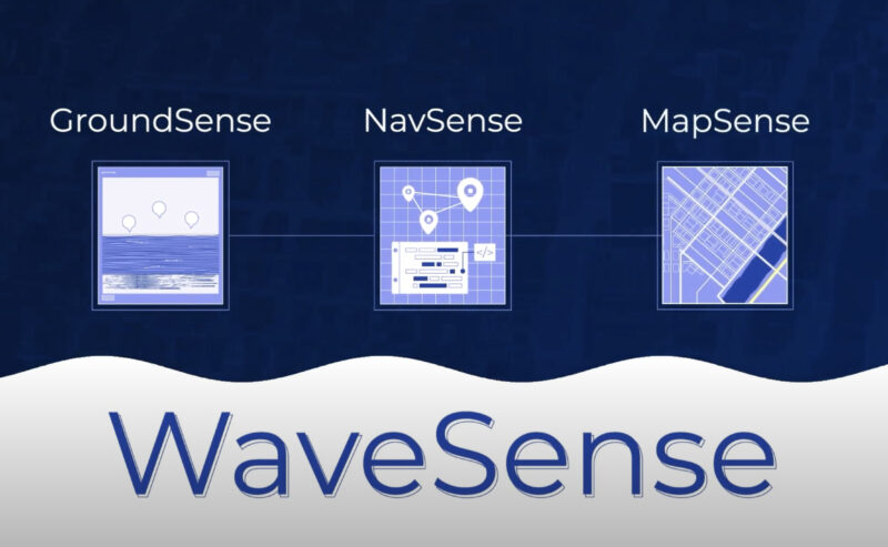
WaveSense Technology

Play Video
Watch

WaveSense Technology

WaveSense is the technology that enables GPR’s all-weather, all-environments subsurface mapping and localization. 

Consisting of three components, our innovative system combines advanced radar technology with powerful software to deliver unparalleled accuracy and reliability in vehicle positioning. 

GroundSense rendering for the WaveSense system

GROUNDSENSE SENSOR

  • Versatile Mounting: GroundSense’s adaptable mounting system allows installation under the chassis at multiple heights for any on or off-road vehicle, ensuring optimal performance across different vehicle types.
  • Modular Design: Modular design scales for applications and system architectures. This flexibility allows WaveSense technology to integrate into various autonomous vehicles.
  • All-Weather Capability: Unlike traditional sensors that can be affected by adverse weather conditions, subsurface radar technology provides reliable data in all environments.
GroundSense sensor feeds detailed data to an autonomous vehicles navigation systems

NAVSENSE SOFTWARE

  • High-Precision Localization: NavSense’s sophisticated algorithm provides localization accuracy up to 5 cm RMS, surpassing many traditional positioning systems in complex urban environments or areas with limited GPS coverage.
  • Flexible Deployment: Designed to be deployable across various compute options, allowing for seamless integration with different autonomous vehicle platforms.
  • Third-Party Compatibility: Features a flexible system interface compatible with third-party localization fusion systems for easy integration with existing autonomous vehicle software stacks. This enhances overall system performance without requiring a complete overhaul of existing technologies.

NavSense intelligently collects and transfers data to MapSense.

Illustration showing how WaveSense can localize autonomous vehicles across

MAPSENSE MAPPING SUITE

MapSense is a powerful software suite that processes GroundSense data to create, update, host, and deploy subsurface maps. It can fuse data from multiple runs into a single map and automatically update existing maps when changes are detected, ensuring the most up-to-date and accurate localization information.

  • Fuses data from multiple runs into a single map
  • Automatically updates existing maps after NavSense detects changes
  • Compatible with commonly used reference systems

Integration and Deployment

System Integration

WaveSense technology is designed for seamless integration with existing autonomous vehicle systems. The modular nature of GroundSense, combined with the flexible software interfaces of NavSense and MapSense, allows for easy incorporation into various vehicle architectures and autonomy stacks.

Testing and Calibration

Once integrated, the WaveSense system undergoes rigorous testing and calibration to ensure optimal performance. This process involves collecting initial subsurface data, creating baseline maps, and fine-tuning the algorithms to match the specific vehicle and operational environment.

Deployment and Monitoring

After successful testing, WaveSense-equipped vehicles can be deployed for commercial operations. Ongoing monitoring and data collection allow for continuous improvement of the subsurface maps and localization accuracy, ensuring that the system maintains peak performance over time.

See the Industry Leaders We’re Partnering with Today

WaveSense seamlessly integrates with existing localization fusion systems, providing a robust solution for everything that moves autonomously.

Developed for commercial operations and rigorously tested in real-world scenarios, WaveSense is ready to revolutionize your autonomous vehicle fleet. Contact us to request a demo.