Subsurface Data and Mapping
Subsurface Data and Mapping for Safety
What is subsurface mapping?
Subsurface mapping develops comprehensive, 3D maps of the underground through the collection of geologic data.
Cutting-edge integrated hardware and software technologies are increasing the accuracy and clarity of the data interpretation for these maps. Bolstering safety along the way, subsurface mapping is used across industries, from automotive companies determined to increase the accuracy of their ADAS and AV systems to utilities looking to monitor their energy infrastructure underground.
What’s clear is that before autonomous vehicles drive on roads and industries break ground on new projects, stakeholders need to understand what’s happening below the Earth’s surface.
Utility
Mining
Construction
Urban development, infrastructure advancements and maintenance, and industrial development all mean the international market for 3D subsurface mapping software is growing at an impressive rate. It’s instrumental in developing reliable, safe and expansive infrastructure mapping for virtually every industry.
Read more to learn about emerging legislative efforts involving subsurface utility mapping:
Emerging Legislation Will Emphasize the Importance of Subsurface Mapping Technology
The infrastructure bill passed by the U.S. Senate has made great strides to improve road and highway construction, support the transition to underground utility pipes, and ensure the safety of the local community. To achieve these ends, special attention must be given to the infrastructure that lies beneath.
Only accurate maps of subsurface data will ensure the reliability and longevity of these changes.
The need for subsurface mapping has never been more important with regulators prioritizing critical infrastructure protection.

The $1 trillion bill includes initiatives such as:
- $100 billion to repair roads and bridges
- $65 billion to update the nation’s electricity grid, including burying utility lines underground to increase resiliency
- $15 billion for removing lead pipes
- $66 billion in new funding for Amtrak and other passenger rail services
This is not the only legislative effort that proves the importance of subsurface utility mapping software.
In order to properly adhere to ongoing infrastructure upgrades, The Colorado Department of Transportation (CDoT) and Montana Department of Transportation (MDoT) have sanctioned subsurface utility mapping and subsurface utility engineering (SUE) for projects. The deployment of precision mapping is a critical asset to meet the requirements for safe, eco-friendly, and efficient roads and infrastructure upgrades.
Absence of Subsurface Mapping Can Cause Accidents and Waste Money
Sectors from automotive, rail, utility and construction now require technology that offers reliable and up-to-date subsurface mapping for better safety and streamlined work processes.
The road’s surface is constantly changing, from daily weather conditions that cause degradation over time to infrastructure upgrades that add new signage and potential obstacles on the road. This is a problem for the automotive industry because current ADAS and AV systems only use surface data, making them unreliable and potentially dangerous. It’s clear that subsurface data and mapping is needed for precise vehicle localization, where next-generation technologies determine where a vehicle is in the world in order to determine how it will behave autonomously. Subsurface data must also be accurate, otherwise it could have disastrous effects for passengers and pedestrians alike.
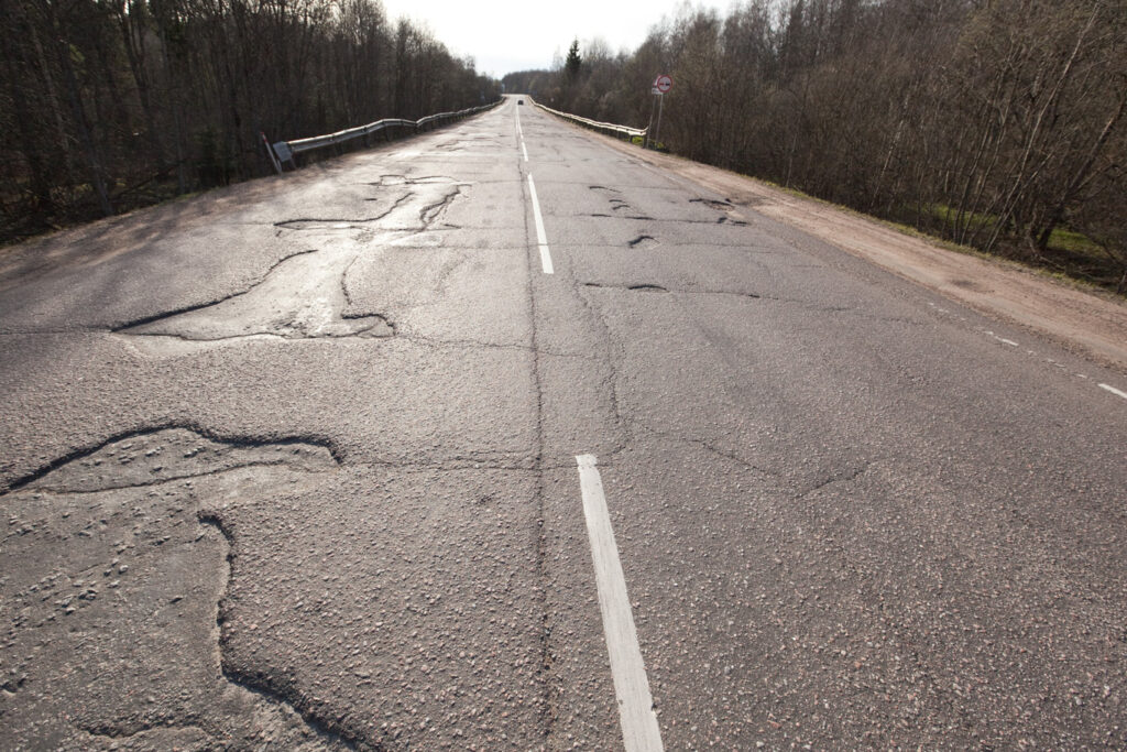
In New York City alone, 51% of roads are marked as “poor,” with potholes, unchecked markings and decaying infrastructure to blame. As a result, drivers must grapple with unsafe conditions on the day-to-day. ADAS and AV systems must also leverage subsurface data that is more stable and reliable than the road’s surface for accurate vehicle localization.
Of the 33,000 vehicle accidents each year, one-third involve poor road conditions.
Unaccounted for infrastructure is a huge problem for the construction industry with maintenance workers breaking ground virtually blind to what lies beneath the surface. The motivation behind CDot and MDot sanctioning subsurface utility mapping and subsurface utility engineering (SUE) for projects is to significantly reduce the number of damages to subsurface infrastructure often caused by the lack of accurate utility location data. Inaccurate subsurface data is costing construction companies and utilities money, so they’re relying on the latest subsurface mapping technology for prevention.
Every six minutes nationwide, an underground utility line is damaged because of inattentive or uninformed above ground maintenance repair. Site plans are unreliable — the sheer size of the challenge suggests subterranean mapping should move away from the pinpointed model currently preferred across industries, to something that can give comprehensive coverage quickly.
There are over 20 million miles of buried utilities in the United States.
As above ground infrastructure becomes less reliable for localization markers for automated driving, and more infrastructure gets moved and updated below ground, it is important for subsurface structures and materials to be detected by technology like GPR’s Ground Positioning RadarTM:
GPR’s technology is the missing sensing component needed for subsurface mapping success.
Which Subsurface Mapping and Data Technology is Best?
There are several mapping technologies being used across the utility, automotive and construction sectors. These include ground penetrating radar, electromagnetic location and building information modeling (BIM).
Integrated hardware and software data systems are increasingly popular for precise detection and clarity of subsurface terrain and data processing for 3D mapping accuracy below the surface.
Every technology has pros and cons, but none are as precise and reliable as GPR’s, Ground Positioning RadarTM.
Data Mapping Comparison Chart
Take a look at the differences between the below systems to see how GPR is superior in subsurface data and mapping:
Ground Penetrating Radar
Uses highly-accurate electromagnetic waves to develop images below the surface of varying materials such as concrete, gas and water infrastructure, and more.
Electromagnetic Location
Can pinpoint metallic materials and utility lines like sewers, gas pipes, and other obstructive objects underground, using radio frequencies. Not used for automotive.
Building Information Modeling
Integrates and manages data to produce a 3D representation of an asset and its entire lifecycle, often used in architecture and construction design and planning.
![]()
Uses ground penetrating radar in conjunction with real-time data tracking to provide precise and reliable positioning information across sectors. GPR’s Ground Positioning Radar™ technology creates 3D maps of subsurface materials and terrain of all kinds for improved safety.
How GPR Enables Subsurface Mapping and Data Collection
GPR’s Ground Positioning RadarTM creates a 3D map of the road’s unique subsurface signatures, enabling new levels of subterranean infrastructure intelligence. GPR’s technology provides accurate and reliable subsurface data regardless of poorly marked lanes and inclement weather impacting the road’s surface.
How it Works
GPR sends low frequency pulses two to three meters into the ground to pick up reflections from below the road’s surface, creating a detailed map that remains stable over time. GPR then matches the results against pre-existing subsurface maps to ensure accuracy and more precise utility mapping. GPR is not disrupted by the surface-level — it offers a quick, accurate, and non-invasive view that other technologies cannot provide.
GPR provides unparalleled safety and cost efficiency while simultaneously improving the quality and usefulness of existing subsurface datasets. Previously used in military settings, our product is now used to reliably and safely provide subsurface mapping across industries.
Uncover the surface by going beneath it:
Learn more by downloading our one-pager on Delivering Production ADAS and Autonomy that Works in the Real World.